Pages

Tuesday 28 April 2020

SWCP Day 18: Paradise after the rain

Other SWCP posts:


Day 18

Padstow to Porthcothan

Approx. 14 miles, 476m ascent

37,752 steps


A bit of an epic day this one, and I have a lot of pictures because it was such a stunning section, so I will do this post slightly differently and mostly just talk you through the pics.


It was a grey and drizzly start once again. After a brief stop in Padstow for supplies from Boots I followed the path out of town and along the edge of the Camel estuary, with views back across to Pentire Point.


I paused at the lookout station at Stepper Point and the sun started breaking through. My boots were already giving me trouble; I had made the mistake of stuffing them with newspaper overnight as they were rather wet, but on removing the paper wad the insole in one of the boots had come loose and was now shifting around and threatening to induce blisters. I had looked for waterproofing spray in Padstow but they only had a missive can, so I would have to survive until Newquay, when I hoped I would be able to sort a proper fix.


Looking onwards to the big headland at Trevose Head, not too many big ups and downs on the way thankfully, as the bag was feeling heavy!


At Trevone bay I stopped for an excellent and much-needed coffee and got a takeaway ham and cheese toasty for lunch. The weather was really brightening up and the sea was a stunning colour. Paddle-boarders making the most of it.


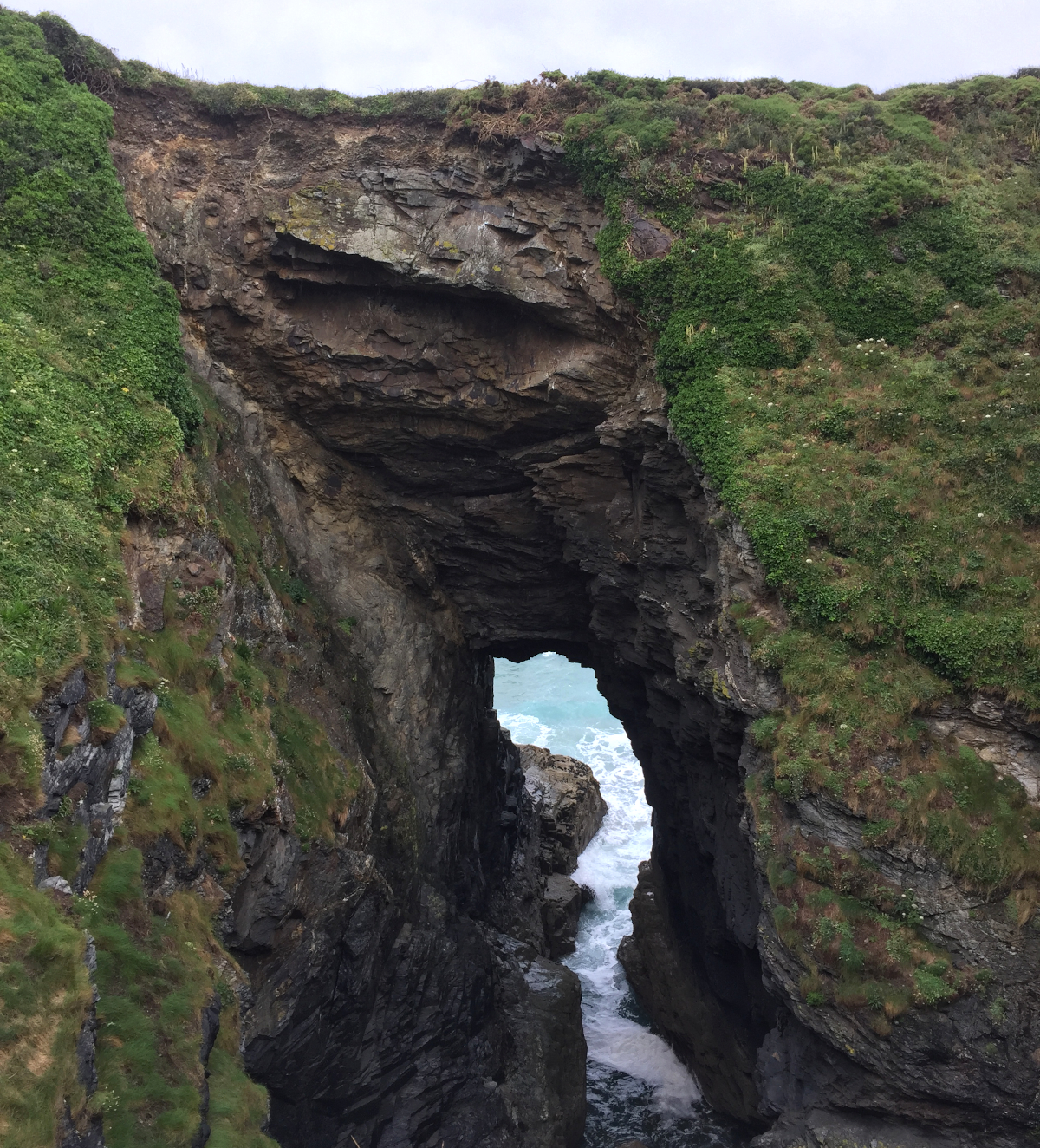
Lots of small rocky islands off this piece of coast, must be a navigational nightmare for boats, but beautiful.


I stopped on a bench overlooking the gorgeous Harlyn bay to eat my lunch. I took off the increasingly uncomfortable boots and aired my feet. A hiker stopped to chat; he was doing the entire coast path but in the reverse direction, having started in Poole about 5 weeks previously. He seemed very settled in to the path and I suspect he was wild-camping; definitely looked rather rugged.


I missed the steps up off the beach and had to back-track, but was soon back to the path and now in the blazing sunshine, quite the contrast to the morning. The view of the lifeboat station heading to the headland, I bet those houses are worth a bit!


Looking back to the Camel estuary, glad I had escaped those clouds, it was nice to be back in fine weather after quite a bit of rain.


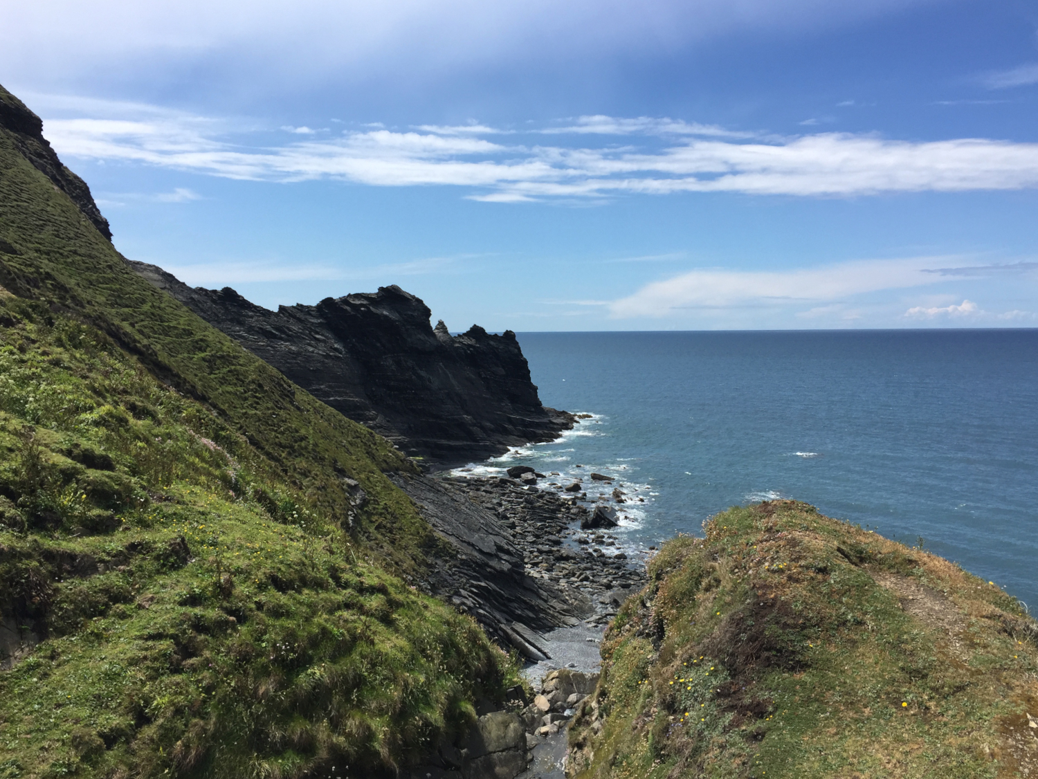
Nearly at Trevose head, and both Mother Ivey’s Bay and Constantine bay are visible on either side of the headland.


Trevose head, with stepping stone rocky islands reaching out into the big blue Atlantic.


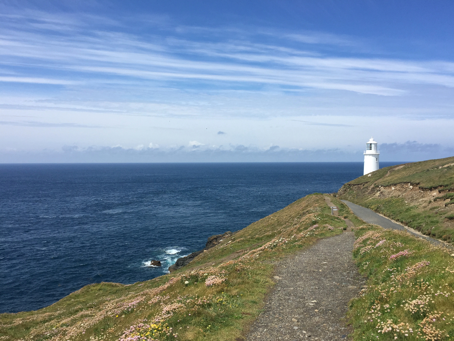
Another lighthouse to add to the collection!


Constantine bay, facing into the wind so quite a different feel to Harlyn, and surprisingly more people, considering how much more sheltered and (dare I say) beautiful Harlyn is.


A delay getting cross the beach at Treyarnon, as they had the beach closed for Doc Martin filming. You can see the group of people with the boom mic in the sea. Presumably Martin Clunes is in there somewhere. I only had to pause for about half an hour whilst they got shots looking up the beach, and then the organisers let me carry on. On the way up the hill I got chatting to a guy digging a trench, he had completed a big section of the path with a mate a couple of years before, running it continuously for about 3 days for charity. I was glad of my more leisurely pace!


I found a passable campsite at Porthcothan. They weren’t really used to hikers I don’t think, and their facilities weren’t great, but they did supply me with a big piece of chocolate cake, which I happily ate in the tent, quite the Friday night party!

Saturday 25 April 2020

SWCP Day 17: Fun in the fog

Other SWCP posts:


Day 17

Port Isaac to Padstow
Approx. 11.7 miles, 891m ascent
31,996 steps


Once again we woke up to persistent drizzle, and unfortunately the wind and rain had found their way in to Mum’s secondhand tent, so she hasn’t had a great night’s sleep. We packed up in the wet, hoping that the weather would improve over the course of the day and I could dry and air my tent in the afternoon. We stopped at the Co-op in Port Isaac so I could get some breakfast and snacks, then I rejoined the path behind the harbour. Mum wisely decided to leave me to the drizzle.

As I was leaving the village I could see the Vic and Helen, the American couple I had met a few days ago and a German couple I’d met the day before, on the path behind me. The path quickly climbed into the foggy rain, and headed round Kellan head after dropping in to the first steep valley of the day. The lonely chilly fog felt properly bleak; my favourite kind of weather for walking! Waterproofs on and hood up, I was in my own dry and warm cocoon and quite happy, a good day to be abroad in Cornwall.

Port Quin

The path dropped down into the pretty little cove of Port Quin, and I was surprised to come across the Vic and Helen, who I was sure had been behind me on the path. They had decided against going out to Kellan head and had taken an inland path, cutting the corner and overtaking me in the process. As we followed the path to the curious little fortress of Doyden castle we got chatting and it was good to have some walking company for a while. I left them behind at Trevan point, but they soon caught me up again on the decent, and we admired the collapsed cave at Lundy hole together, the sea roaring in and out of the rocky archway below. 

Looking down into Lundy hole
The Rumps and The Mouls in the distance

As we approached the Rumps and Pentire point they decided to cut inland again and head straight for Polzeath, so we parted ways and I headed out into fog once more. The Rumps is a promontory that juts out into the raging Atlantic, reaching out to the little Mouls island further out to sea. The headland is the site of an Iron Age fort, with some of the earthworks still visible. It seems like it would be a rather bleak location for a settlement, but perhaps it wasn’t so exposed all those years ago. 

I cut inland towards Polzeath, and once again bumped into Vic and Helen, who had stopped for coffee and cake in a gateway. We walked the last easy section into Polzeath together. I first visited Polzeath for a surfing holiday as a 16 year old. A friend arranged a trip for a big group of us, staying on the eccentric Robbie Love’s campsite, and I got my first taste of surfing. I remember it as an amazing week, feeling very adult to be off on holiday all on our own. The boyfriend and I, and the friend that organised the original trip, visited Polzeath for several years in a row after that, for surfing and camping. It got far too busy and expensive though and we reverted to South Wales and other parts of the South West. The town has undergone a flurry of development in the last few years, with plenty of massive glass-fronted houses popping up all over, and cranes indicating more to come.

Coming onto Polzeath, lots of surfers even on a bleak day!

In the town car park I was surprised to come across Mum, who had decided to see if she could bump in to me (iPhone friend tracker!). We went for lunch in the beachside cafe, then I was reunited with my big backpack for the last section to Padstow, as Mum had had enough of the wet weather so had decided to head home. Of course being such an excellent support team, she had already been to the campsite in Padstow and pitched my tent for me!

Up the Camel estuary

It was a bit of a shock to have the big weight back on, so I was glad the last section to the ferry at Rock was easygoing. The views up the Camel Estuary were delightful, with little sailing boats skipping about in the wind, and the weather was finally improving. I remembered the walk to the ferry as we had frequently visited Padstow when holidaying in Polzeath, although I had remembered it as quite a trek; now I was used to big miles it felt like only a tiny hop between the two.

First ferry done!
Pretty Padstow harbour

I was rather excited to take the ferry, the first one of many required to complete the coast path. The crossing was very pleasant, and was made more entertaining by the presence of a cat on a lead, everyone acting as if it was the most normal thing in the world. I disembarked in Padstow harbour in the early afternoon, had a little wander round the town, and stocked up on pasties, studiously avoiding the many Rick Stein establishments. The campsite for the night was a little out of town along the camel trail. Dennis cove campsite is really excellent, all the amenities including a much needed drying room, and a very lovely receptionist who I chatted to for a good while whilst charging my phone in her office. The weather much improved, I ate my dinner pasty in the evening light.

Wednesday 22 April 2020

SWCP Day 16: Deep in slate country

Other SWCP posts:


Day 16

Tintagel to Port Isaac
Approx. 9.1 miles, 789m ascent
27,976 steps


The damp weather continued overnight, but at least the wind dropped to a more sensible level, and we were greeted by only a fine drizzle in the morning. We packed away the tents ready to relocate further down the coast, and headed back to Tintagel for a decent full english breakfast. Suitably refuelled, and a pasty in the backpack for lunch, we made our way back to the path via the pretty clifftop church, built in the 11th or 12th century. It has a really interesting floor out of slates laid on their edges, in a chequerboard pattern. The first section of the path out of Tintagel was fairly easy-going, staying high on the craggy cliffs, passing interesting slate mine remains, some lonely pillars of rock remaining. We were definitely in slate country, with herringbone walls dissecting the fields. We passed by the Youth Hostel, perched high above the sea, definitely one to stay in in the future!


Imposing cliffs
Good to have company!
Slate quarry remains, Gull Rock in the background
Good walls

A couple of miles on and the path dropped sharply down into the rocky cove of Trebarwith Strand, with Gull Rock standing prominently out to sea. Mum and I parted ways on the beach front, and I made a start on the epic set of steps heading back up the hill out of the village. Just as soon as I gained the 100m summit, the path plunged down again to sea level, and I was very pleased to only have the small backpack with me once again. The ups and downs continued, but apart from feeling rather tired the walking didn’t feel too hard, and the views and flower-filled valleys made for very enjoyable scenery. 

Trebarwith Strand, waving bye to Mum!
Flower-filled valley

I chose a particularly picturesque valley for a lunch spot, glad that the weather had brightened up over the course of the morning. I settled into the slope of the hill and found myself in danger of dropping off to sleep, enjoying the calm sounds of the nearby sea and a gentle breeze. I jolted back to it when a couple of hikers passed me a little while later and persuaded myself to get back to it. I had just a couple of valleys left to conquer, before the long level section running on to Port Isaac. I made it into adjacent Port Gaverne by mid-afternoon, and met up with Mum, who had already scoped out the secret campsite we had been tipped off about. It was in a nice little field next to a stream, and very cheap. 

The sun breaking through
Port Gaverne bay

The sun properly came out, and we had a relaxing couple of hours dozing in the sunshine. At dinnertime we made the short walk up into Port Isaac, hoards of Doc Martin fans photographing all the key filming locations. We got some fish and chips and found a bench with a view above the harbour, carefully guarding our dinner from the attention of the Herring gulls circling around us. A walk around the village in search of phone signal to call home, then back to the tents, now joined by some fellow hikers who were obviously also in on the secret site location.

Dinner company!

Monday 20 April 2020

SWCP Day 15: Into the Wild

Other SWCP posts:


Day 15

Crackington Haven to Tintagel
Approx. 11.5 miles, 1,065m ascent
26,272 steps


During the night the wind whipped up until it was gusting at about 50mph. We were very glad of our sheltered corner of the campsite, but the wind and rain still woke us through the night. In the morning we hunkered in the shelter of the campsite kitchen to make tea and breakfast, and debated whether it would be a good idea for me to continue to walk with such high winds. As it was blowing on shore I decided to go ahead, and to cut inland if the path looked too close to the edge. We planned to stay at the same campsite for another night, so I got away quite promptly without any packing required. Mum wisely decided to give the morning walk a miss, and we arrange to meet in Tintagel in the afternoon. 

I set out into the wet and blustery weather and very shortly came across the American couple from the day before, who had decided to turn back due to the high winds. Feeling like I was perhaps being very foolish in carrying on, I headed out to the lonely cliffs, and suddenly crossed paths with a magnificent fox, going about its business. For some reason this helped settle my nerves, and after cutting inland a little at the first headland to avoid the cliff edge, I wasn’t worried about being in any danger. As predicted, the strong wind was blowing straight inland, so I wasn’t at any risk of being blown over the edge. A lot of the path was also set a little in land in a peculiar landscape of scrubby rockiness in amongst old collapsed cliffs. I really enjoyed the mysterious terrain, and it felt properly like Cornwall.

Wild scrubby cliffs

I’m surprised looking back at the stats for this day that it was so much ascent, as I remember it being a very enjoyable and fairly easy-going walk. I’m apparently well-suited to wet and wild weather, much more so than hot sunshine! The roaring sea and blasting winds just made me feel extremely ALIVE and full of energy. The huge cliffs and spectacular wild Cornish coastline also helped to speed the walking along. At Pentargon, cliffs formed a deep sheer-sided inlet, with waves crashing and roaring in and out of the caves below, the path scrambled up the sliced rock, with gulls wheeling in the space in between.

Foals utterly unfazed by the roaring sea below

The view coming into Boscastle was magnificent, and with the sea whipped up below, the narrow harbour entrance looked like an impossible route to the calm waters inside. I dropped down the hillside from the headland and found the NT cafe for some lunch and a warm-up. It was surprisingly busy in the village, considering I hadn’t seen a soul since the American couple first thing in the morning. I was pleased to see the village was in very good shape and had clearly bounced back from the horrendous floods that had washed it away in 2004.

Boscastle harbour

After a good hot bowl of soup and the obligatory hot chocolate (was it really mid June?!), I wasted a bit of time browsing the extensive gift shop, then headed back out into the wild once more. The path quickly climbed back up out of the valley, then followed some slightly gentler cliffs, still with spectacular views of the craggy islands just offshore. At Rocky valley the path descended, finally out of the wind for a brief moment. I had been here before many years ago with some friends; at the wooded head of the valley there are some ruins with strange and possibly ancient symbols carved into the rock, the mystical pull of Tintagel not far off. The valley is extremely pretty, and dotted with rockfalls and waterfalls that the path picks its way around, and back out the other side. 

Lookout above Boscastle
Craggy coastline, wild seas

A mile or so further on and I spotted Tintagel. The wind was absolutely howling, having built and built through the afternoon, so I cut off the final headland and headed straight into the village to meet Mum. Tintagel is certainly a strange place, it is a bit over-commercialised, trying too hard to sell the King Arthur legend, with every other business having some sort of related name. We quickly escaped and headed back to the campsite at Crackington Haven, and after a shower and a change into dry clothes went back to the same pub as the previous night, as the food had been so excellent. 

After dinner we made use of the lovely TV room at the campsite, grateful to be out of the weather for the evening. Shortly after, we were joined by the only other campers on the site. The couple were also hikers, but on a somewhat more epic mission, walking all the way from Lands End to John O’Groats. We compared notes, and they spread their maps out over the table to plan their next day, as the route-planning was slightly more technical than my approach of just keeping the sea on my righthand side. They were also keen to get off the coast path as they weren’t enjoying the massive amount of ascents and descents! I followed their blog over the next few weeks, and was pleased to see they made it to the end in August, completing the route in 81 days.

Saturday 18 April 2020

SWCP days 12-14: A Cracking Weekend

Other SWCP posts:


Days 12-14

2 rest days

Bude to Crackington Haven

Approx. 10 miles, 760m ascent
27,828 steps


Two very lazy rest days at home, all washing done and the tent aired and dried out. Mum decided to join me for another few days, so we headed back to Devon on Sunday evening, staying with a friend to get an early start on Monday. It was a very good move as Mum’s friend gave us a tip off about a secret campsite near Port Isaac, in the perfect location close to the path. We stayed up far too late catching up, and after a good breakfast in the morning we didn’t get a particularly early start. We made it to Bude at about 9.30am, and after getting a pasty for lunch we got back to the path, which leaves Bude where the locks of the historic canal meet the beach.

Leaving Bude

The path quickly rose to the tower at compass point, then followed the top of the cliffs, undulating gently across green fields. The weather was a bit unsettled, with showers coming and going as clouds rolled across the sky. At Upton we passed a house with a big stack of books for sale, neatly arrange in a wheelbarrow. We hoped they weren’t getting too wet in the showery weather. In sight of Widemouth Sand Mum turned round to return to the car, and I continued on, making use of the toilets in the carpark, and pausing to watch the surf schools playing in the white water.

Looking back to Widemouth

After Widemouth the hills reappeared, with lots of amazing rocky cliffs and flower-filled valleys. There were lots of other walkers on the path, and we continued to leapfrog each other as we took breaks at different times. I got chatting with a few groups, including a speedy American couple that kept leaving me behind on the hills; I later learned they were in their 70s! I timed my lunch stop badly and the heavens opened, but I enjoyed my pasty whilst huddled in my waterproofs in a comfy grassy hollow.

Rocky coastline 
Scary path!
Ridges out to sea

After lunch the weather improved and the sun finally made a proper appearance. The crowds and stunning views continued, and I passed through a lovely valley, filled with bright flowering heather and a curious plant called Dodder, which forms tangles of orange and red growth, parasitising other plants such as gorse. I saw it all over the place on the north coast, and it gave vibrant colour to the hillsides.

Heather and Dodder
The final climb to St Gennys above Crackington Haven was a good one, gradually winding up the headland jutting out into the sea. The path then plunged back down into the village below, and I met Mum at a cafe, sitting in the sunshine with a cup of tea. We found the lovely (and empty!) campsite at Coxford Meadow, and set up in a perfect spot out of the building breeze. We had an excellent dinner at the Coombe Barton Inn, and had a wander on the beach in the lovely evening light.

Crackington Haven beach