Pages

Tuesday, 12 May 2020

SWCP Day 23: Artists' light

Other SWCP posts:


Day 23

Godrevy point to St Ives

Approx. 9.6 miles, 300m ascent

29,007 steps


The day started grey and drizzly, but by the time my Grandparents dropped me at Godrevy point the clouds had cleared away and it looked like it would be another hot and sunny one. The section today was easy and quite short, skirting round the vast entirety of St Ives Bay. A day of very golden sands and plenty of people. As the walking would mostly be on sand and tarmac I elected to leave the walking poles behind for once. It was also a big milestone day, as the map books I was using were split into three separate books, and the first one finished in St Ives. I would finish the day with 232 miles down, well over a 3rd of the path complete!

To St Ives!

I found my way to the official path route, which weaves through the mass of sand dunes behind the big beach at Gwithian. I stopped to take pictures of the sea thistles stuffed full of snails (enjoying the moisture?) and got chatting to a dog walker who turned out to be a warden at Cape Cornwall, where I would be walking in a couple of days. We agreed it was a spectacular spot, and much preferable to the tourist trap at Lands End, which did have the claim of being just a few metres further west that the Cape.

Snails

I headed off into the dunes, pleased that there were quite obvious large slate markers showing the way through the maze. However, the ups and downs were completely blocking the sea breeze and I was quickly far too hot, so I found a path down to the beach, hoping the tide was far enough out so I could follow it all the way to Hayle. I had timed things right and I had a clear route, so had an easy hour or so just walking on the sand and enjoying the lovely weather, now with a welcome breeze. 

More dunes!
Back on the beach

At the Hayle estuary the beach is bisected by the river flowing out to sea, with many warning signs that the water is too fast and too deep to wade or swim across. This is rather infuriating, as it involves a diversion of a couple miles up to Hayle to the nearest bridge, then back down the other side of the river, only to return to the beach about 100m from my current location. Somewhat grumpy at failure of the people of Hayle to install a bridge just for my purposes, I set off up the estuary, on an unexciting pavement beside the road. Arriving in the town, I decided I couldn’t be bothered with another couple of dull miles of pavement walking, so I located a bus stop and was soon alighting in Lelant on the other side of the estuary. 

Up the Hayle estuary

I found my way past the church back to the beach, dodging golf balls from the nearby course on the way. A brief stop for lunch in the dunes, then I found my way down to the sand, deciding to risk that the steps at the other end of the beach would be accessible, as I had heard conflicting reports on whether that route was possible. Another glorious half an hour of beach strolling and I was pleased to find it was possible to scramble up, despite the steps being half collapsed and washed away.

More sand
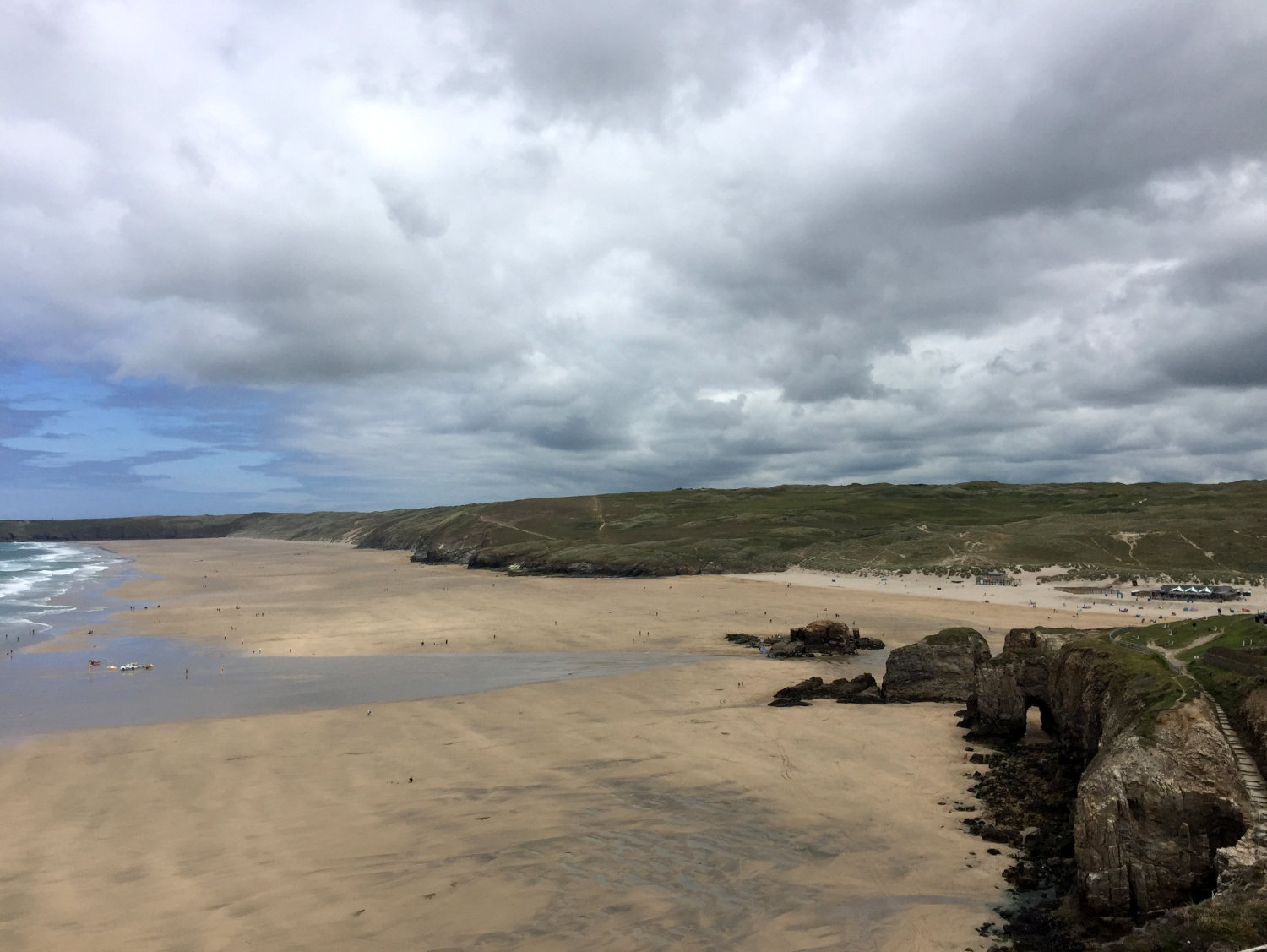
Looking down on the stunning Carbis Bay

At this point the weather was really heating up, and for the first time on my walk I was getting a bit low on water. I had mostly been over-cautious and carried at least 1.5 litres every day, usually with several opportunities for a refill on the way, as running out of water was a bit of a fear of mine. I had just taken my smaller 800ml bottle on this day and hadn’t had a chance to top up yet. However, I tried not to be overly concerned as I wasn’t exactly deep in the wilds! I dropped down into the gorgeous Carbis bay, but the beachside restaurant looked far too posh for me to walk in and request water, so I headed on, only a couple of miles away from St Ives. The path thankfully headed up into the trees on the cliffside; a welcome bit of shade after several hours in the full sun.

Approaching St Ives through the trees
Looking back at the day's walk, Godrevy lighthouse on the far left
Good coffee 
I shortly arrived into the centre of St Ives, and found a cafe for a cold drink and cake whilst I let the Grandparents know where I was. I found the excellent booze shop that I had remembered from a holiday the previous year, and stocked up on a few local beers as a thank you to the Grandparents for their excellent support. I made my way through town dodging tourists, stopping for a very good coffee at Mount Zion, then around the little headland at St Ives head, giving a full view of the day’s walk back to Godrevy point, the sea the most incredible colour. I met the Grandparents near the Tate at Porthmeor, fully in love with beautiful St Ives despite the mad crowds.

The most ridiculously blue sea

Saturday, 9 May 2020

SWCP Day 22: Surf's up

Other SWCP posts:


Day 22

St Agnes to Godrevy

Approx. 15.6 miles, 830m ascent

36,941 steps


Back to drizzly damp weather once again!  A luxurious start to the day with breakfast served to me by the Grandparents, then straight off the campsite back to the path, just the little backpack in tow. As the campsite was a bit short of St Agnes I first followed the path through the little town, noting the large number of Finisterre jackets and coats out and about, as the brand headquarters is on the outskirts. I was very pleased with my extravagant but lovely and warm jacket that I’d been using in the cooler evenings, from said brand. After getting directions to the somewhat hidden path back out of town from a dog-walker (Finisterre-clad), I was away and heading along the very picturesque section to St Agnes head.

Interesting gate on the Blue Hills
On the path out of St Agnes
Looking out to Bawden rocks from near St Agnes head

The weather was pretty bleak, but as usual I felt full of energy walking in the lower temperatures, probably also helped by the transition back to only the small backpack. The path dropped down to the little beach at Chapel Porth, and despite it being a Tuesday the carpark was well-filled, with lots of people taking advantage of the very good surf breaking in bay. I hear that Finisterre staff can take time off when the surf is up, plus the Surfers Against Sewage headquarters was also close by, so clearly plenty of people making the most of living in beautiful Cornwall. I watched the surfers for a while and enjoyed a hot chocolate and flapjack in the shelter of the cafe, not warm enough to investigate their ‘Hedgehog’ ice cream!

The strange parasitic plant 'dodder' that I saw everywhere near the path

I climbed back up to the top of the cliff and was shortly dropping back down again into the small bay at Porthtowan, just stopping to make use of the public toilet facilities, then back up the hill again. The next section followed the chainlink fence-line of yet another military installation, this time the disused chemical weapons base at Nancekuke common. Unsurprisingly given the horrific  implications of the research and other work that went on there when it was active, the place has a very unsettling vibe, and I made a very rapid pace to get that bit of path out of the way, slightly impeded by the very overgrown hedges and muddy terrain.

Very pleased to get clear the base, and tummy rumbling, I followed the path down into the slightly downtrodden looking town of Portreath, not fancying my chances of a decent lunch. However, I was shortly pleased to find close to the seafront a very lovely cycling shop with adjoining cafe, that served an excellent and indulgent smoked salmon and avocado sandwich. Plenty of coffee along with some cake later, and a tip-off to look out for seals on the way to Godrevy, I got back to it.

Carvannel Down, look at that path!
Looking towards Godrevy head

The path dropped down into the final steep valley of the day at Carvannel Down, the angle of the cliffs giving a spectacular view of the path and cliffs ahead, looking all the way along to Godrevy lighthouse. I wound back up the other side of the valley, and the last 5 or so miles to Godrevy was mostly level. The weather worsened so I stopped to put on my waterproof trousers, then really got motoring for those last few miles, enjoying the views from the cliff-top path, whilst safe and dry in my waterproof cocoon. I kept my eye out for seals but unfortunately there were none to be seen, but I did spot several kestrels hunting in the open landscape.

Godrevy lighthouse, St Ives in the distance
Despite the long mileage I made very good time to meet my Grandad at the carpark in Godrevy, rather catching him on the hop as he was hoping to give the dog a walk before I arrived! We headed back to the campsite near St Agnes, and I was soon fed and watered and well-ensconced in the comforts of the caravan.

Thursday, 7 May 2020

SWCP Day 21: Sands of Time

Other SWCP posts:


Day 21

Crantock to St Agnes

Approx. 9.5 miles, 560m ascent

30,366 steps


I woke up raring to go, and made a fairly early start despite only having a relatively short distance to do. I would be meeting my Grandparents in St Agnes in the afternoon for another few days of familial support, and giant-backpack-free walking. I found my way back across Cubert common, without getting quite so lost in the sand dunes, and rejoined the path at Holywell bay, with the skies a little brighter than the day before. 

The path out of Holywell
Holywell bay in the morning sunshine

The path quickly rose above the beach to Penhale point, skirting the edge of another old military site. Again the vibe was really off and spooky, lots of old equipment and antennae littering the landscape. The route passed a strange lonely house on the clifftop, then turned the corner and was in sight of the massive expanse of Perran beach, with Perranporth visible a couple of miles away along the long sandy stretch. I had timed it right and the tide was out so I could walk the entire length along the sand; no need to get lost in the sand dunes! I found the firm strip of sand in the middle of the width of the beach, and settled in to a couple of easy miles, with just a few kite surfers and dog walkers for company on the empty northern part. 

Perran bay, looking towards St Agnes head
All the sand

When I was planning the walk I had thought it would be an excellent opportunity for some quality thinking time. All those miles, and I needed to consider what I was going to do after the path, as I had no job to go to and very little plan for the future. It was a strange time, and the walk was a useful marker and an achievable and finite task. However, I found that I thought of very little at all whilst walking, even when on easy and monotonous stretches like the beach. I didn’t feel bored and I didn’t need to listen to music or podcasts or anything, my mind just floated along, mostly empty except for perhaps considering what the next meal might be. It was very pleasant, but not so useful for making big life decisions and plans!

Finally coming to the end of the beach a couple of miles of sand later, I reached the little town of Perranporth, and went on a lunch hunt, settling for a veggie street food place which did the most excellent homemade nachos and chilli. Suitably well-fed I found my way back out of town and back up onto the clifftop, with spectacular views back along Perran beach. Just out on the cliff and watching my step on the narrow gravelly path, I spotted a bunch of keys looking lost, and moved them to a more prominent spot in case their owner returned. A short while later a runner passed, looking like they were on the hunt, so I pointed them back to the spot, and they were very grateful to be reunited.

Delicious lunch!
Expanse of Perran beach
Looking back again
Old quarries and collapsed mines

The last stretch towards St Agnes was easy walking, mostly level through old quarries bordering a little airfield, and views along to the headland and to the Bawden rocks out to sea. I made excellent time and by 2pm had found my way to the lovely little Caravan club site that my Grandparents had pitched their caravan on, just a little way off the path. It was great to have some company again, and their bouncy golden retriever Peggy was full of beans and very pleased to be out and about in Cornwall with lots of new places to explore. After a short walk together out to the cliffs, I thoroughly enjoyed making use of the excellent caravan amenities, with my tent pitched outside for my own bedroom space.

Rocky coast continues
Looking down to St Agnes

Sunday, 3 May 2020

SWCP Day 20: Hunting Roast Beast

Other SWCP posts:


Day 20

Rest day

Crantock to Holywell bay loop

Approx. 6.7 miles, 270m ascent

24,487 steps


With almost 200 miles done, I was due a rest day, and as the campsite near Crantock was really nice and also cheap, and had the full complement of laundry facilities, today was the day for it. I had a good lie in and then got all my laundry done in the morning sunshine, I even got some bonus time on the tumble drier as someone seemed to have left loads of time on the clock, win. I also worked on a fix for my walking boots. I gave them a good clean and re-waterproofed with Nikwax liquid, and stuck down the insoles with the glue I’d bought in Newquay. Fingers crossed the fix would work as I didn’t want to have to buy new boots! I knew that cheap Regatta boots were a bit of a gamble when I set out, but having had the same brand before I knew they would fit well out of the box with minimum time to break them in, and I hoped they would at least last the 630 miles of the path. It was also probably my lazy lack of maintenance that had damaged them; I resolved to look after them better for the rest of the walk.

I had a good lunch at the campsite cafe, excelling myself with a big sausage roll followed by an excellent cream tea, then napped for too long in the afternoon sunshine, only waking up when the breeze got up and the sun disappeared. Feeling rather groggy I decided to head out for a walk around the headland for some fresh air and to chop off a bit of the route for the following day. I also needed to find somewhere for dinner, as I’d disappointingly missed the cutoff for ordering the campsite Sunday roast dinner. The idea of a roast had been put in my head though, so I hoped I could find a decent local pub.

Pentire Point West
Looking back to Polly Joke

I rejoined the coast path at West Pentire, and made my way around the headland to Porth Joke (locally called Polly Joke). There were plenty of weekend walkers out and about, and kids body-boarding in the small waves in the bay. On top of the hills there were several fields of bright red and yellow poppies, giving lovely colour to the scene. I followed the path round to the big expanse of sand at Holywell, the stormy skies looking very atmospheric above the big Gull’s rocks out in the bay. I then went on the hunt for some dinner, starting at the pub in Holywell, which unfortunately wasn’t serving evening food. After a rather expensive half-pint, I headed back up the hill to Crantock, getting rather lost across the dunes and golf course on Cubert Common. I was beginning to hate sand dunes!

Stormy skies 
Atmospheric
Holywell bay
I found the pub in Crantock, very disappointingly no roast in the evenings, so I had to settle for a mediocre burger, some food at least! I made my way back to the campsite, finding some pretty gardens to admire as I made my way back to the village. Back to it properly tomorrow!

Friday, 1 May 2020

SWCP Day 19: Crowds and Chaos

Other SWCP posts:


Day 19

Porthcothan to Crantock

Approx. 14.5 miles, 450m ascent

38,112 steps


For once I awoke to a dry and bright morning. My feet were a bit of a mess from walking in boots with a slipping insole all of the previous day, so as it looked like a fine day I decided to wear my walking sandals and give my feet a break from the boots. I was glad of my decision to bring sandals that were substantial enough for walking in; I’m not sure I could have done another day in damaged boots! I got away quite promptly from the campsite, now into the routine of getting everything packed away efficiently. I presented myself at the beach shop and cafe for their opening time, and got a coffee and pastries for breakfast. 

Porthcothan beach
The lighthouse at Trevose Head just about visible in the distance

A bit of procrastination talking to some locals then I was on my way. The path rose gently above Porthcothan bay, and after a small dip at Porth Mear I was soon on the high cliffs looking down on the spectacular Bedruthan steps, a collection of boulders and stacks scattered along the long golden beach below. There were quite a few people out enjoying the Saturday morning sunshine, and I made use of the NT facilities before escaping the crowds. 

Bedruthan steps
The other end of the steps 
Looking down on Mawgan Porth beach

Another short high section and the path dropped down onto the massive beach at Mawgan Porth. I took off my sandals and enjoyed walking barefoot in the sand, finally warm enough to do so! I found an excellent village shop with an extensive bakery, and got (another!) pasty for lunch, opting for chicken and chorizo as an exciting diversion from the usual Cornish variety. A couple of small headlands and I was overlooking the huge expanse of Watergate bay. The path dipped down into a carpark that was populated by far too many BMWs, and I found a pleasant grassy spot for my lunchtime picnic, overlooking the many kite-surfers below.

The expanse of Watergate bay
Rain showers ahead!

As I approached the outskirts of Newquay the weather decided to chuck in a couple of short sharp showers; always entertaining to watch everyone scrambling for waterproofs and umbrellas. The path meandered through the urban sprawl of Newquay, deciding to take a couple of pointless detours to headlands, only to pop out 50m further down the same road I had already been on. In the town proper, I found an outdoor shop and got supplies to mend my boots: Some glue, cleaning brush and waterproofing liquid. I made my way to the tourist information office, my original intention being to find accommodation close to central Newquay. After another 10 minutes of busy town though, I decided I couldn’t cope with the chaos after so long in the wild, too many people and things and noise. 

The spectacular Gannel

After studying the map I realised there was a promising campsite a couple of miles to the west in Crantock, so decided to carry on. There are a couple of different ways of crossing the Gannel estuary and escaping Newquay. I decided to opt for the little ferry at Fern Pit, so had a dull mile or so walking through suburban streets through Pentire, declining to take yet another diversion out to Towan Head. The sun was really warming up, and I was very pleased to finally see signs for the cafe and ferry. I was quickly vindicated in my route choice though, as the cafe overlooking the ferry point was a delight, with wonderful gardens clinging to the steep hill dropping to the estuary below. The views were stunning, I’ve never seen such incredibly green-blue water.


Ferry number 2!

The ferry was a little wooden boat with an outboard, and the crossing only took a couple of minutes. There was some sort of triathlon race going on, with the swim in the estuary, so there were plenty of people on the other side of the water. I weaved through the crowds and found my way off the beach and quickly got lost in the sand dunes behind, failing to follow the ferryman’s directions. I eventually found my bearings and realised I had overshot the campsite, with a little backtracking along the road required. I finally found the lovely campsite at Treago farm, made all the better for being only £5 per night, and therefore confirming my decision to take a rest day tomorrow. 

I pitched in a nice quite spot and was able to get a delicious chilli con carne to takeaway from the campsite shop and cafe, pleased I didn’t need to go out anywhere to find something for dinner, as it had been quite a long day.